

Geological Background
of Thar Coal Deposits.
As per researchers, several Ice
ages (Glacial and Inter- Glacial periods) have occurred in the 6 billion years of geological history of earth. During
Glacial periods the sea level dropped.

A number of factors in the past, interacted to produce
conditions favoring the formation of ice sheets. Some of these factors include
Fluctuating sea-levels during the geological time contributed
to the preservation of many Coal environments
worldwide.
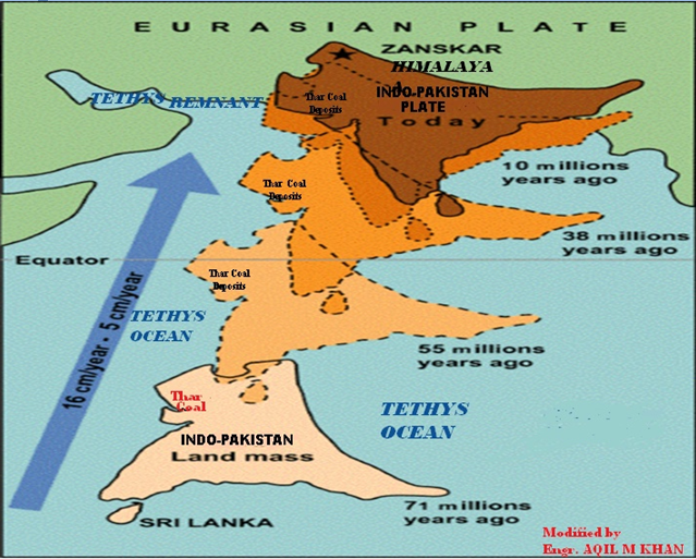
From Pangea to the Modern Continents.
According
to the geological investigations of plate
tectonics, at some 300-290 millions years ago,
there was one super continent Pangea on Earth which first split into two continents.
The one in the north was called Laurasia and the
other one, located more towards the south, Gondwana.
Gondwana split up into several smaller pieces after an end of past Ice age in the mid-Jurassic period, some 200-160 million years ago, most of its parts including
African continent started moving in the southern hemisphere.
later Indo-Pakistan plate split off from African plate about 90-100
million years ago in Cretaceous period and fused with the Australian
Plate. After that it began to move towards north, at about 16 cm per year and
collided with the Eurasian Plate.
Related video:
Research scientist Enriqueta Barrera presented her
findings at the Geological
Society of America ,seventy-one million years ago, the Earth's continents were
covered by shallow sea and sea level was much higher (lightly shaded areas), provided appropriate
conditions for
plants and trees that once grew in extensive swamp
and coastal marsh areas of Indo-Pakistan
landmass.

Researcher Barrera found evidence for long-term gradual high-latitude cooling and a rapid and sharp decrease in deep ocean temperatures---possibly as much as four degrees lasting over a million-year time span beginning about 71 million years ago.
She concludes that "both oceanic and continental
changes occurred in conjunction with a suggested 150-foot
drop in sea level.
Barrera speculates that the drop in sea level may have dried
shallow areas of the Tethys coastal region.
Based
on above research, it is concluded that the plants and trees in the dried
coastal swampy and marsh shallow areas of Thar,
died and their remains sank to the bottom of the western Tethys coastal areas of Indo-Pakistan landmass due to
again rise in sea level or land subsidence.
Between (70- 45 million years),several
time the trees and plants grew and died forming layers of Peat due to repeated fluctuation in sea level and
sedimentation on the coastal areas.
Peat Slices of Time:
Related
video:
Warm
to moderate temperatures and high humidity alone do not produce all the
conditions necessary for creating coal deposits. Steadily rising sea level and/or steady regional swamp subsidence are
also necessary. As a prerequisite to the formation of thick coal seams it is
necessary that the rate of
vegetable matter accumulation remain in general equilibrium with the rate of
rising water levels for relatively long periods. Rise too fast, and the swamp
gets drowned, rise too slowly and dead plant material is not completely submerged
when it falls to the swamp floor where it will decay or oxidize rather
than be preserved.
An
example of above is Wood Fossil
Park Jaisalmer India, where stood a
forest 125-135 millions years ago Jurassic era,
about 70 million years older than Thar Coal. Fossilized
tree trunks are of various sizes and kinds with the largest being 13 meters in
length and 1.5 meters in width. At that time (130 millions years ago) Jaisalmer
area of India was submersed into the Sea
when Indo-Pakistan landmass was still attached
with the African continent, supported by a hot
and humid climate , the above tree trunks got preserved in the form of fossils
wood because they were not subjected to required burial pressure under rocks to
convert into coal. Covering
about 10 sq. Km of baren land, the Fossil Park contains 25 petrified trunks, in
total. The 21-hectare preserved area of the park lies about 17 Km from
Jaisalmer.
Due to the collision of Indo-Pakistan plate with Eurasian
plate, tectonic
and metamorphic evolution of the Central Himalayan Domain in Southeast Zanskar
(Kashmir, India) occurred. The old mountains, sedimentary and metamorphic
rocks settled on the disappearing
Tethys ocean floor by their own weight and the
volcanoes that fringed its edges had
uplifted and formed mountain ranges known as "Himalayas"
and the Tibetan Plateau.
Because of the above
great geological happening, a lot of energy splashed out into the atmosphere,
resulted in blockage of Sun light to earth and beginning of recent past Ice age.
Geological
records indicate that during the late Pleistocene period, the Himalayas
constituted a frozen mass and there were glaciers in place of rivers. When the climate warmed,
these glaciers began to break up and the frozen water trapped within surged
forth in great floods to inundate the alluvial plains on
Indo-Pakistan landmass.


As collisional orogeny (In
geological terms, ‘‘Orogeny’’ refers to the process of
mountain building.) progressed through geological time, material eroded from the rising
Himalayan ranges was transported southward by a variety of ancient emerging river
systems which en route to ocean basins. Among
these, the Sindhu and the Saraswati were major rivers that flowed from the
mountains right down to the sea at Rann of Kutch as shown below.
Origin of Saraswati river.
Relative video:
In its long
journey, the Saraswati is believed to have had three tributaries — the
Shatadru (Sutlej) originating from Mount Kailas, the Drishadwati from the
Shiwalik Hills and the old Yamuna. These flowed together along a channel
presently known as the Ghaggar river ( also known as the Hakra River in
Rajasthan) and the Nara in Sindh.
Changing courses of ancient rivers and emergence of Thar desert
and Aquifers.
RD
Oldham Britisher (1886) was the first geologist
who argued logically, pointing to the great changes in the drainage pattern of
the rivers of Punjab and western Rajasthan that served to convert a once
fertile region into a desert.
Recently It is estimated by Central Arid Zone
Research Institute (CAZRI) India that the Saraswati river flowed through Rajisthan between One million and 40,000 years ago.

According
to experts who have studied the map of all relevant underground channels,
mighty Sarawati was probably 1.5 km wide and five meters deep. Approximately 10000- 6000 years ago, Saraswati was one of the rivers of great splendor
in this region and flowed down the
Himalayan slopes roughly parallel to the Indus, about 100 miles to the east.
As reported by Prof. Ahmad Hasan Dani (Ed. Indus Civilization
-- New Perspectives, Quaid-i-Azam University, Islamabad, 1981, pp.3- 12), the ancient and now
defunct river Saraswati [now reduced to a seasonal stream called the Ghaggar]
has a fascinating geological story. The tectonic movements in the past,
pushed up the Aravalli hills, in northern Rajasthan and changed the drainage
pattern of the Northwest Punjab rivers drastically.

The mighty river dried up roughly 4000 years ago due to techtonic shifts of the earth. Due to these shifts, water supply to the river was cut off. Saraswati lost her major tributaries, Yamuna and Sutlej. Sutlej turned west and joined Beas- Sindhu system, and Yamuna migrated east to join Ganga. Yamuna(Jamuna) also pirated Saraswati's sources and the remaining waters seeped down below the earth from the fissures.

As a result of above geological changes, the greenery of
Rajasthan was lost, replaced by an arid desert where hot winds piled up dunes of sand. The flourishing Hurrupian civilizations
vanished one by one.
As late as the 16th century AD, the
floodwaters of Sutlej flowed down Saraswati. Even today, Ghaggar; a puny
seasonal river, occupies some parts of Saraswati's dry beds. Eventually only
floodwaters flowed through her vast channels.
Reviewed Report of Central Arid Zone Research Institute (CAZRI)
Jodhpur India.
Recently
through satellite imagery, aerial photographs and field surveys,scientist at
the Central Arid Zone Research Institute (CAZRI)
Jodhpur and Babha Atomic Research Center India have confirmed that the mighty sarawati river first of all ran through the
Thar desert.

The abandoned
channels of the
frequently shifting Sarawati
river now lie buried deep under the voluminous pile of
aeolian sands and silts of the Thar
Desert characterized by a variety of dunes.
The water and soil beneath the earth of lost
Saraswati river were researched. Samples of waters have been taken on the tracks of the Old
courses of Saraswati.

Recent high resolution oxygen-isotope dating of the material shows that the large number of the buried channels of the Saraswati still contain sweet water as old as 22,000 to 6000 yr BP( Before Present) in the 60 – 250 m deep aquifer and 5000 to 1800 yr BP at the depth of 30 – 50 m below surface in the Jaisalmer district (Nair et al., 1999) and 12,900 to 4700 y BP in Cholistan (in the Hakra reach of the Saraswati) (Geyh and Ploethner 1995).
Near Jaisalmer a palaeo channel at the depth of 450 – 500 m has yielded 40,000 year old sweet water, and in the acquifer
shallower than 200 m the water is 17,000
to 9000 year old (Reddy et
al., 2011).
Interestingly, in the vast realm
of brackish groundwater
the discharge of the paleochannel-derived fossil water is showing no sign of decline despite over-exploitation.
Very significantly, the absence or near
absence of tritium in the fossil water shows that it is not the
rainwater that percolated down to these depths.
Saraswati reappears in Rajasthan.
Few wells dug along
the old tract have yielded sweet water only at 30 to 40 metres.
Related video:
Recent Historical Earthquakes in Thar & Rann of cutch area.

Past Mughal period 1524 and 1668 earthquakes in Sindh resulted in mass
destruction of coastal settlements, and permanent changes to the coastline and
change drainage of major rivers further towards west.
The 1819 earthquake in Rann of Kutch, bordering Sindh
region, was associated with thrust uplift of upto 30 feet along Allah Bund fault and was reported as having resulted in major sea inundation,
change in the course of Indus river, Nara river and subsidence of Old Indus Delta.
The
dry bed of the Ghaggar-Nara river and the buried courses of the Saraswati still yield surface water in the desert
which is now contributed by the Himalayan
monsoon precipitation.
Do we
have any research Institute like Central Arid Zone Research Institute India
which could search possibility of converting our arid zones of Cholistan and
Thar in Pakistan to make them green and fertile agricultural lands, utilizing
the possible aquifers in the region?
Present shape of Thar coal deposits is the product of all the
geological changes have occurred in the past in Thar coal area, discussed above.
No comments:
Post a Comment
Note: Only a member of this blog may post a comment.