Prospects of Underground Coal Gasification in view
of the Specific Geological formation of Thar Coal Deposits.
All
fossil fuels will eventually run out and it is essential that we use them as
efficiently as possible.
Significant
improvements continue to be made in industrially developed countries, in how
efficiently coal is used so that more energy can be generated from each ton of
coal produced.
The
most economical method of coal extraction from coal seams depends on the depth,
the quality of the seams, the geology,
the hydrology and environmental
factors.
World
Coal Deposits Vs Thar Coal Deposits.
Coal
is called a fossil fuel because it was formed from the remains of ancient plants and vegetation that have undergone sedimentary and metamorphic transformation
over millions of years.

Worldwide most of the coal deposits were formed 300 million years ago, from the compaction and indurations of
accumulated remains of plants and trees that once grew in extensive swamp and coastal marsh
areas.

As
the water level of sea or lake dropped due to any change in geological or
climatic conditions, the forest in shallow
areas became dried, the plants and trees died, their remains sank to the
bottom of the swampy and marsh areas due to fluctuating sea level, which had
little biological activity at its bottom, led to preservation of the plant
leaves, stems, pollen and other structures.
Over
long periods of time, the makeup of the earth's surface changed, and seas and
great rivers caused deposits of sand, clay and other mineral matter to
accumulate layer upon layer. Several hundred feet of sediments layers continued
to accumulate and added weight, eventually forming a soggy material called peat. Sandstone and other sedimentary rocks were
formed, and the pressure caused by their weight squeezed water from the peat. Increasingly deeper burial and the heat caused chemical
changes associated with it gradually changed the peat
to coal of different grades worldwide.
Process of Coalification.
Coal formation began during the Carboniferous
Period (known as the first coal age), which spanned 360 - 290 million years
before present. Coals
formed
during the first coal age are
older, so they are generally located deeper in the earth's crust. The greater
heat and pressures at these depths produces higher-grade
coals such as anthracite and bituminous coals in
Europe and North America.
Coal formation continued throughout the
Permian, Triassic, Jurassic, Cretaceous, and Tertiary Periods (known
collectively as the second coal age), which spanned 290 - 1.6 million years
before present. Conversely, coals formed during the second coal age under less intense heat and pressure
is generally located at shallower depths. Consequently, these coals tend to be lower-grade sub bituminous and lignite coals (like Thar Coal deposits Sindh
Pakistan).
Geological
Time Scale.

The
path of peat to coal transformation could be shown as a function of pressure, temperature
and time as under.
Plants debris -> peat -> lignite -> sub-bituminous coal -> bituminous coal -> anthracite coal -> graphite
(a pure carbon mineral)
-> Diamond.

Peat
is an unconsolidated accumulation/ deposits of plant remains from a
water-saturated environment such as a bog (marsh)
or mire (swamp).The process of peat accumulation continues until
terminated by an event like an invasion of a nearby river channel, a marine
transgression, or unfavorable climate. Each time shorelines retreated coal
swamps migrated with them, along vast deltas which received seemingly limitless
supplies of sediment sank to the bottom of the coastal areas.

During
deep burial the peat undergoes Coalification process which
squeezes out up to 98% of the water and some of
the volatile hydrocarbons. The older and more deeply-buried a coal seam is, the
less water and volatile matter it contains.
Bedded and compacted coal layers are geologically considered
to be rocks. Because peat is not consolidated or
compacted, it is classed as organic sediment. Lignite and bituminous ranks are classed as organic sedimentary rocks.
Metamorphic rocks are comprised aggregates of minerals formed by the recrystallization of pre-existing rocks in response to changes of pressure, temperature, or volatile content. Anthracite Coal, formed when bituminous beds of coal are subjected to the folding and regional deformation affiliated with drifting and tectonic mountain building processes, is listed as a metamorphic rock.
Metamorphic rocks are comprised aggregates of minerals formed by the recrystallization of pre-existing rocks in response to changes of pressure, temperature, or volatile content. Anthracite Coal, formed when bituminous beds of coal are subjected to the folding and regional deformation affiliated with drifting and tectonic mountain building processes, is listed as a metamorphic rock.
Paleontology of Thar Coal Deposits.
Paleontology seeks information about several aspects of past
organisms and tells us Earth's organic and inorganic past. On the basis of
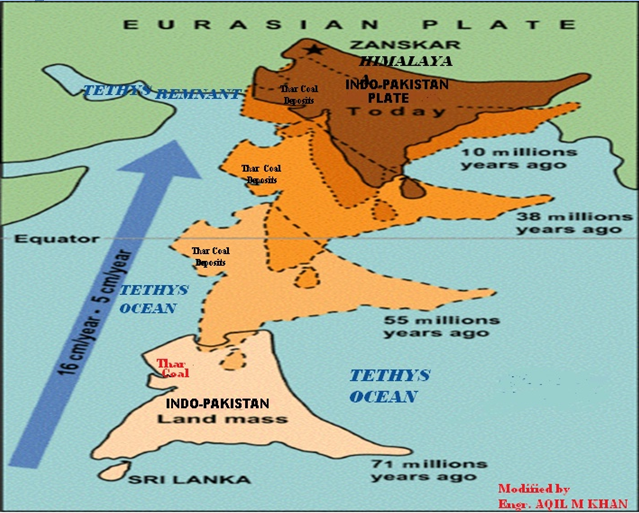
paleontological information the Thar coals are Paleocene to Eocene in age; Paleocene-Eocene
eras 66-
44 million years ago while Indo-Pakistan landmass was drifting towards Eurasian
plate shown below. Available evidence indicates that the Thar coals may have
been deposited in a raised-bog environment landward of a west trending
coastline of Tethys sea on Indo-Pakistan land
mass, forming a low rank coal deposits (one of the youngest coal deposit
in terms of formation).
Geological Background of Thar Coal Deposits.
Present shape of Thar coal deposits is the product of all the
geological changes have occurred in the past in Thar area, discussed in the
above link.
RANKS OF COAL.
Peat, an unconsolidated accumulation of partly decomposed
plant material, has an approximate carbon content of 20
percent. In many classification schemes, peat is listed as the initial stage of
coal formation. Moisture content is quite high, at least at the 75 percent level.
When dry, peat has an oxygen content of about 30 percent, is flammable, freely but inefficiently burns slowly and steadily for months at a low heat-content value of 5,000- 5,400 Btu’s per pound.
When dry, peat has an oxygen content of about 30 percent, is flammable, freely but inefficiently burns slowly and steadily for months at a low heat-content value of 5,000- 5,400 Btu’s per pound.
A
method of classifying coal based on the amounts of carbon and volatile matter
it contains, is known as Rank of coal.
The ratio
of fixed
carbon
to
volatile
matter is used to determine a
coal's rank. The higher the ratio, the higher its rank. It signifies
the degree of coalification of organic material.

Forty
seven percent (47%) of World Reserves are Low
Rank Coals and fifty three percent (53%) are
Hard Coals in terms of moisture and carbon contents.
As
the amount of moisture increases, the coal has a lower heating value.
The
use of coal depends on its chemical composition and how much moisture it
contains. The above sketch shows the types of coal and their specific uses.
The amount of energy produced by a
ton or a pound of coal is largely dependent upon the type of coal being burned. The above four major
categories of coal, each differing in composition and age. Lignite, also known as brown coal, is the
least valuable of the four, in terms of energy production.

Organic
part of the coal primarily contains carbon, hydrogen and oxygen with some
sulfur and nitrogen.
The
inorganic part of the coal is much less than the organic part and usually
contains a large number of ash forming
compounds.
Discovery of Thar Coal Deposits.
Thar coal deposits were discovered
accidentally in the year 1989, during an exploration project of defunct SAZDA
(Sindh Arid Zone Development Authority) to find drinkable water in the desert. The size and the quality
of Thar Coal reserves were known to a great extent since1992- 93 after a study by John T Boyd Company, US Mining
consultants. Thar Lignite Coal resource was initially estimated to be around 135 billion tons which was subsequently enhanced
to 175 billion tons after review of data by USGS (United States Geological Survey) and GSP (Geological Survey of Pakistan). This estimate was based on distanced bore holes over an area of 9,000 sq kms. Subsequent a constricted explorations
carried over an area of 1,200 sq have provided even higher figures of proven reserves of being around 200 to 350 million tons of lignite per sq km.
As
per reports, the Thar Lignite Coal resources are equivalent to around 50 billion tons of oil, which is more than the
combined oil resources of Saudi Arabia and Iran. In terms of gas reserves,
these are around 68 times the present resources of natural gas in Pakistan (resource estimation will be discussed later).
Configuration Of Thar Coal Deposits.
Thar Desert is a desolate
region where sand is piled up into huge wind blown dunes. The soils of the desert
are generally sandy to sandy-loam in texture which is a personal observation
during Thar Coal visit. As per reports the low-lying loams have a hard pan of
clay, calcium carbonate, silica and gypsum. Several minerals and
petroleum also found below the ground level of the Thar Desert.
The dominant clay stones represent low-energy shallow-water
conditions, whereas occasional thin sandstone beds and siltstone within clay
stone show that the area was periodically affected by flood events.
Thar Coal Overburden.
Overburden is the waste rock material
overlying the Coal seams (layers of coal), also called spoil. It
is removed to reach the coal seams and either dumped or used in reclaiming
mined areas. As per reports, Thar Coal overburden consists of three kinds of material; dune sand, alluvium and
sedimentary sequence.
Dune
sand is an accumulation, mound or ridge
of sand formed by wind. Winds are the driving force behind sand dunes
that have so significantly shaped and modified the surface of land. Generally,
active dunes (unvegetated dunes) have a gentle slope on their windward side.
During wet periods, rate of dune migration commonly decreases, enables
vegetation to encroach onto the margins of the sand mass, stabilizing the
margins and inhibiting further movement along them.
Alluvium soil
deposits are formed when the rivers slowly lose their carrying capacity due to
decrease in velocity. While slowing down, a river loses its potential to hold
the large soil particles in a suspended state and these particles thus settled
dawn on the river bed or flood plains.
Sedimentary rocks
are those rocks
made up of pieces of other rocks. The sedimentary rocks we see today were once
gravel, sand, silt, mud,or living things (Sea shales,Trees, Plants etc),
carried by water or wind , characteristically
laid down in strata which are initially horizontal or nearly so and
deposited on the surface of the land.
Educational
video:
Sedimentary
structures and mineralogy of a sandstone may distinguish whether it is of
Aeolian (wind- blown dunes), fluvial (river- born) or marine origin.
As per reports, the Thar coal total overburden is around 150 to 230 meters. The
various Coal seams start at around 150 meter
depth and occur up to 215 meters. The thickness of the
lignite seams varies greatly from place to place in Bara formation and
discontinuous, separated by silt or clay parting.
The roof above Coal seams and
the floor rocks under Coal seams are clay stone
and loose sandstone beds, making an envelope ( 50- 65
meter thick) for a deposit of discontinuous Coal seams.
Creation of Ground waters/ Aquifers.
As discussed in the above link, the river systems of the past
have several flow regimes associated with them. The most common is the surface
flow. River channels have sometimes hundreds of feet of sand and sediment
deposits. There is groundwater in these sands and this groundwater flows
through this sand or even through subsurface bedrocks.
Another type of underground flow is when there is a
subterranean cave system. Surface waters can disappear underground and flow
through such caves. So the underground flow of the Ghaggar-Saraswati
river is really groundwater flowing along the present and abandoned channels
replenished by monsoon water from the channels and the surrounding plains. Some
places this groundwater appears at the surface as springs.
Rates of groundwater flow vary depending on permeability of
the aquifer and hydraulic gradient. So the groundwater system associated with
the above rivers drainage is likely to be a series of disconnected aquifers
being recharged primarily through monsoon discharge of the old rivers channels.
Also the monsoon floods and repeated Sea inundation in the area affects the
water table at various depths.
Hypothetical Sketch
of Thar Coal Aquifers
depth of 50 m, 120 m and more than 200
meters:
Ø
One aquifer above the coal zone:
Ranges between 52.70 and 93.27 meters depth.
Ø
Second aquifer with the coal zone at 120 meters depth:
Varying thickness up to 68.74 meters.
Ø
Third aquifer below the coal zone at 200 metes depth:
Varying thickness up to 47 meters.
Ø
Water quality is brackish to salin
Chemical Composition of Thar coal:
The weighted average chemical analysis of the coal samples of
the four blocks
show variation and are as given below:
Moisture
(%) 43.24 to 49.01
Ash
(%) 5.18 to
6.56
Volatile
Matter (%) 26.50
to 33.04
Fixed
Carbon (%) 19.35 to 22.00
Sulphur
(%) 0.92 to 1.34
Heating value (Btu/lb)
As
Received 5780 to 6398
Dry
10723
to 11353
DAF
11605 to 12613
MMM
Free 6101 to
6841
The knowledge of the
geology, geometry, Hydrology and the quality characteristics of the specific Coal deposit are
of the utmost importance in designing it’s efficient exploitation.
Underground Coal Gasification:
History.
The
prospect of recovering the energy of coal from deep or unmineable deposits
through Underground Coal Gasification was
first suggested by two German
engineers,
brothers Carl Werner and Carl Wilhelm
Siemens, in 1868 over 144
(hundred
forty four) years ago.
The
first experimental work on UCG was planned to start in 1912
in Durham, the U K, under the leadership of Nobel Prize winner
Sir William Ramsay. However, he was
unable to commence the UCG field work before the beginning of the World War I, and the project
was abandoned.
In
1913, Ramsay's work, attracted the attention of Viladimir
Lenin of Soviet Union who recommended the experimentation of underground
coal gasification. Ultimately an extensive program of work carried out in
various places of Soviet Union between a period of 1920-1955,
but wasn't
developed experimentally until the first half of the Twentieth Century in
Soviet Russia. These activities resulted in several pilot plants and five
industrial sized UCG plants in the 1960s, but efforts were abandoned as large
natural gas discoveries made the process uneconomical. Today of these only the Yerostigaz plant Angren, owned by the Australian Linc Energy in
Uzbekistan remains.
On the basis of Soviet research work ,later
the efforts for underground Coal gasification began in countries like USA, Britain, Poland etc.,
the criteria for the process was based on the following factors.
i)
The minimum cumulative thickness of
combustible coal shall be 10 feet and the individual combustible coal beds
shall be separated by no more than 5 feet of non-combustibles( overburdens).
ii)
The depth of overburden shall be more than 500 feet but less than 2000 feet, selected as the maximum depth of
Soviet experiments.
iii)
Overburden permeability should be
substantially less than the natural permeability of the coal.
iv)
There shall be no fertile acquifers in the
roof rock directly above the coals and the coal seam should not be a desolate
acquifer.
v)
Roof
and floor rock material preferably shall be composed of shale or clay or relatively plastic rocks.
vi)
The topography at the project site should be
suitable for drilling holes
and for the installation of surface facilities.
vii)
The proposed site should be sufficiently
remote to avoid interference with neighboring operators.
The Past and present Underground Coal Gasification Pilot Projects
activities.
·
Underground
gasification was trialed in the UK during the 1950s
at near Bayton, near Cleobury Mortimer in Worcestershire, but was later
abandoned – and at the time questions were raised in British
Parliament about
the environmental impacts on communities up to
10 miles away.
·
The United States of America had studied the concept of UCG
during 1970’s because of energy crises. In USA Livermore’s 1970s test site at Hoe Creek, Wyoming,
unfortunately resulted in contaminated groundwater, as did one pilot in Carbon
County, Wyoming. At Hoe Creek, operation of the burn cavity at pressures higher
than that in the surrounding rock strata pushed contaminants away from the
cavity, which introduced benzene, a carcinogen, in potable groundwater. Since
these problematic tests in the 1970s,most of the projects have served to identify various
risks and problems: groundwater contamination, leaking byproducts like benzene,
seismic instability, and other issues
·
The
costs of electricity produced with UCG based syngas were estimated in the study
of the University of Indiana USA. The average
cost of electricity production in 2010 in the
state of Indiana according to the report was 5.7 cents per kWh, which at
present makes exploitation of UCG in Indiana economically difficult since only
seams up to 3.5 meters thick are available at depths greater than 200 meters.
The number of holes drilled and depth and thickness of coal seams ( thin coal
seams exhaust quickly thereby
terminating the gasification process after short intervals and considered
uneconomical for UCG like most of European deposits) also a key cost effecting
factor. So the 3-3.5 meter thin coal seams are
left unused in UCG process.
·
Syn
gas can be burned as it is, but is a relatively dirty fuel in its raw state due
to presence of excessive CO2 that is why expensive carbon captured and storage ( CCS)
techniques are being proposed with UCG.
Carbon Capture and Storage (animation).
Leakage
of CO2 out of reservoir is a major safety concern. Even stable rock formations
shift in earthquakes. Seismic activity presents a danger of undoing all that sequestration. Because CO2 is denser than air,
when it leaks out of the ground it forms an invisible, undetectable cloud that
pools near the ground and displaces the oxygen, suffocating any life nearby.

As per report, this has happened naturally and
given us a vision of what could occur:
in 1986, Lake Nyos in Cameroon released a
large amount of CO2, silently killing nearly two thousand people and a large
number of livestock as shown above.
·
It
is alleged that once extracted, Syn gas can also be
liquefied, allowing it to be used as feedstock for gas-to-liquid processes like
diesel etc. China’s Coal to Liquids Program have been prohibited in the
United States. Producing oil from coal is a technology that has been around for
a long time. Germany used it to fuel its tanks and aircraft during World War II
and South Africa is using it today to provide about 30 percent of
its gasoline and diesel supply. But as reported (June 29, 2011) Institute for Energy Research, United
States have stymied coal to liquid plants and shut out of that market for
military use because it is argued
that Coal to Liquids process life cycle greenhouse gas emissions would be
higher than that of conventional oil and has proven a lucrative
& expensive business.
·
As
per report Sydney (Platts)--8Jul 2011,the
Queensland state government has permanently shut down Cougar Energy's
underground coal gasification pilot plant at Kingaroy in eastern Australia.
The Department of Environment and Resource Management said it had advised Cougar that only "rehabilitation and monitoring" could be conducted at the project. "No further underground coal gasification will be permitted at the site," the DERM added.
The Kingaroy underground coal gasification pilot plant was ordered closed in July 2010 after water quality tests found two isolated readings of 2 parts per billion of benzene in a nearby groundwater monitoring bore.
The Department of Environment and Resource Management said it had advised Cougar that only "rehabilitation and monitoring" could be conducted at the project. "No further underground coal gasification will be permitted at the site," the DERM added.
The Kingaroy underground coal gasification pilot plant was ordered closed in July 2010 after water quality tests found two isolated readings of 2 parts per billion of benzene in a nearby groundwater monitoring bore.
Another
environmental concern is that the void created by gasification may cause the
land surface to subside. Subsidence is likely to be more of a problem if
gasification occurs in a shallow coal seam, closer to the surface.
.
Brief About UCG Process &
Problems Encountering in View of Thar Coal Deposits.
Gasifying
coal underground involves drilling two wells into a suitable coal seam,
igniting the coal at one well and pumping in air or oxygen enriched air.
Because the amount of oxygen available in air is limited, the coal only
partially burns to provide heat and carbon monoxide will be the main combustion
product which can then be piped to the surface and burned there.
Obviously this is not going to be a
particularly efficient process since much of the energy liberated will go into
heating up rocks underground. In order to try to make the process a bit more
efficient,controlled amount of water is
usually injected along with the air/oxygen. When it comes in contact with the
superheated rock some of that heat can be used to split the water (H20) into
hydrogen and oxygen which react with more of the coal and additional reactions
such as below.
CO
+ 3H2 < =
> CH4 + H2O + Q( HEAT)
CO2 +
4H2 < = > CH4 + 2H2O + Q(HEAT)
Controlled
amount of water injection keeps the reactions to produce a mixture of combustible
gases, including hydrogen, butane, methane, carbon monoxide and carbon dioxide.

This
mixture of gases is known as syn gas which is removed from the second well and is
quite similar to the town gas that was made from coal during the 19th
and much of the 20th century in America and Europe. The
above method of introducing steam, somewhat increases the efficiency of
the process but as per reports even so around 25-40 percent of the energy embodied in the
coal is lost in heating surrounding rocks during the Underground coal
gasification process.
The
underground coal gasification is a complex physico- chemical process and as per
reports, water is unavoidably added into the reaction zone by leakage from
surrounding formations. The rate of ground water influx into the gasification
zone has an important influence on the reactions and the product gas. With higher level of natural water specially aquifer’s water intrusion, the heating value of the product decreases and becomes inconsistent (by increasing the CO2 concentration at the expense of CO and H2)
and making it uneconomical to utilize even at
source/site for power generation.
Energy that enters into process (coal,
oxidizer) is equal to output energy (syngas) and residual energy (unburned
coal, ash, tar). Control of expenditure and energy consumption (compliance with
the law of conservation of energy) is based on material balance and heat
balance of the process which is used for the purpose of tracking temperature
changes. Heat balance allows us to track the impact of temperature changes on
the gasification process and the proportion of obtained energy in the form of
the gas from the process. Specifically
the presence of such pressurized aquifers surrounding Coal Seams, does not permit Material and Heat (Energy) balance
calculations, essential to run the
process economically.
Thar Coal Media Reports.
Related vdeos:
Conclusion and Suggestions.
·
In
1961 Soviet era, an experimental UCG facility near Angren Uzbekistan, commenced
gasifying a sub-bituminous coal seam at a depth
of between 100 and 250 meters ranging 3-24 meter thick. It is the only longest
operating UCG facility. The
results obtained from specific Underground Coal Gassification Angren field
Uzbekistan and Escom South Africa, can not
be duplicated in Thar lignite field because of the adverse geological and
hydrological conditions at Thar Coal, discussed above.
·
As the UCG process progresses, the chamber fills with
rubble, ash and char. When the process reaches the roof of the coal seam, more
of the barren overburden will be exposed, Clearly
this is not going to be a particularly efficient process since much of the
energy liberated will go into heating up rocks.
·
One
of the most serious problems in Underground Coal Gasification specifically like
Thar Coal deposit, is the presence of pressurized Aquifers. If there is too much
water, underground fires won’t be able to burn for long as these will be doused
by the underground water lead to failure of the project.
·
For
any combustion process, the material and heat balance calculations are carried
out in order to carry out the thermal
efficiency audit of the process
essential to run the process
economically which is not possible under the prevailing hydrological conditions
at Thar coal deposits.
·
Under prevailing geological and hydrological conditions of
Thar Coal deposits, discussed above, sustainable & efficient production of
Syn gas with required amount of heating value for power generation is a
question mark and need to be reviewed.
·
In
view of the above discussion, Open-cast or Open pit mining is an appropriate
option which allows maximum and efficient utilization of such kind of lignite
deposits as Thar Coal.
(Discussion continue)